Regional plans, long-range plans, and other system-level transportation planning documents.
Regional Transportation Planning#
-
ABC Comprehensive Plan, Chapter 6: Transportation (2025 Update)
The transportation element of the adopted Albuquerque/Bernalillo County Comprehensive Plan guides land use and mobility decisions, covering a multimodal system, safe access, travel choices, coordination, and implementation policies for the city and unincorporated county.
-
MRMPO 2045 Metropolitan Transportation Plan
Establishes the Albuquerque metropolitan area’s adopted long-range transportation vision through 2045, including regional growth assumptions, multimodal needs, safety and equity goals, funded projects, performance measures, and implementation priorities.
-
MRMPO 2045 Metropolitan Transportation Plan - Full Appendix
Preserves the plan’s complete supporting appendix, including technical methods, demographic and travel forecasts, project evaluation, public and agency input, environmental analysis, financial assumptions, and federally required documentation.
-
Transitions 2045 Executive Summary (archived PDF)
Summarizes the adopted metropolitan plan’s regional trends, goals, multimodal investment strategy, safety and equity approach, project priorities, environmental resilience, and implementation framework through the 2045 planning horizon.
-
Resumen ejecutivo de Transiciones 2045 en español (PDF archivado)
Presenta en español el resumen oficial del plan metropolitano hasta 2045, incluyendo tendencias regionales, objetivos, seguridad, equidad, inversiones multimodales, resiliencia ambiental, prioridades de proyectos e implementación.
-
MRMPO Metropolitan Transportation Plan Hub
Provides the maintained regional entry point for the 20-year transportation blueprint, related public outreach, the Target Scenario, long-range system guidance, archived plans, and future plan-update information.
-
Metropolitan Transportation Plan Archive
Preserves earlier Albuquerque metropolitan transportation plans, chapters, appendices, project lists, financial analyses, performance measures, environmental-resilience work, public outreach, and long-range system guidance from the 2030 through 2040 cycles.
-
Transitions 2045 Public Outreach
Documents public engagement conducted from 2023 through the plan’s April 2025 adoption, links the participation plan, explains how feedback informed the MTP, and provides current presentation and engagement contacts.
Historical Metropolitan Transportation Plans#
-
MRMPO Connections 2040 Metropolitan Transportation Plan (2020 Archived PDF)
Preserves the complete 2020 regional plan covering demographic and travel trends, land-use scenarios, roadway, transit, bicycle and pedestrian networks, safety, freight, resilience, finance, and implementation.
Official MRCOG PDF · MRCOG MTP Archive
-
Appendix A: Metropolitan Transportation Plan Project List (2020 Archived PDF)
Lists funded, near-term, and long-term regional bicycle, pedestrian, roadway, preservation, safety, operations, and transit projects, with locations, descriptions, lead agencies, planning costs, and anticipated timeframes. Official MRCOG PDF
-
Appendix B: Illustrative Project List (2020 Archived PDF)
Documents unfunded regional projects that could enter the metropolitan plan if resources become available, including Albuquerque-area roadway extensions, interchange reconstruction, transit, trails, and supporting implementation requirements. Official MRCOG PDF
-
Appendix C: Projects of Regional Interest (2020 Archived PDF)
Records the 2020 status of major regional proposals, including the Gibson extension, I-25 projects, Mesa del Sol interchanges, Atrisco Vista, Paseo del Volcan, and cross-river connections. Official MRCOG PDF
-
Appendix D: Financial Plan Detail (2020 Archived PDF)
Details the revenue forecasts, maintenance and operations costs, capital funding, project expenditures, local sources, federal programs, transit assumptions, and fiscal-constraint calculation supporting Connections 2040. Official MRCOG PDF
-
Appendix E: Long-Range Transportation System Guidelines - 2020 Update (Archived PDF)
Preserves the 2020 regional guidance for land-use context, multimodal networks, roadway design, right-of-way, intersections, traffic calming, bicycle and pedestrian infrastructure, road diets, and performance measures. Official MRCOG PDF
-
Appendix G: Recommended Pathways (2020 Archived PDF)
Compiles regional implementation strategies for mobility, active transportation, economic connections, and resilience, including Complete Streets, road diets, safety audits, transit, connectivity, land use, freight, and climate adaptation. Official MRCOG PDF
-
Appendix I: Federal Performance Measures and FAST Act Report (Updated 2022 Archived PDF)
Preserves MRMPO’s updated federal targets and supporting resolutions for roadway safety, infrastructure condition, system performance, transit asset management, and public-transportation agency safety planning through March 2022. Official MRCOG PDF
-
-
MRMPO Futures 2040 Metropolitan Transportation Plan (2015; Modified 2017 Archived PDF)
Establishes the region’s 2040 transportation direction through growth scenarios, multimodal system needs, project and funding strategies, safety, environmental considerations, performance measures, and a September 2017 administrative modification.
Official MRCOG PDF · MRCOG MTP Archive
-
Futures 2040 Appendices A-P (2015; Modified 2017 Archived PDF)
Preserves project lists, scenario and safety methods, emissions analysis, long-range system guidance, outreach, funding projections, maintenance assumptions, performance monitoring, and the September 2017 Appendix A modification. Official MRCOG PDF
-
-
Preserves the complete 2035 regional plan and appendices, documenting growth forecasts, multimodal needs, project priorities, financial constraints, environmental analysis, public involvement, and amendments adopted through May 2014.
-
MRCOG 2030 Metropolitan Transportation Plan: Pedestrian Element (2008 Archived PDF)
Establishes the Pedestrian Composite Index, maps walking priorities and missing sidewalks, and frames regional policy, accessibility, project, grant, and multimodal implementation needs. Official MRCOG PDF · MRCOG MTP Archive
2026 Long-Range Transportation System Maps#
-
Long-Range Transportation System Guide
Explains how MRMPO coordinates future roadway, bikeway, pedestrian, and transit networks, applies Complete Streets principles, supports regional activity centers, and guides development review and long-term infrastructure investment.
-
Long-Range Transportation System Guide (June 2026 PDF)
Preserves the adopted 94-page guide covering multimodal networks, land-use context, street design matrices, right-of-way, national best practices, road diets, safety priorities, green streets, retrofit evaluation, and a Complete Streets checklist.
-
Maps the Albuquerque metropolitan area’s adopted long-range pedestrian network, identifying existing and proposed pedestrian-priority facilities that support regional planning, project development, and implementation beyond the 2045 planning horizon.
-
Maps the adopted long-range roadway network for the Albuquerque metropolitan planning area, including existing and proposed major facilities used to coordinate growth, investment, project development, and regional connectivity.
-
Interactive Long Range Roadway System Map
Provides an interactive view of MRMPO’s Long Range Roadway System using May 2026 data, complementing the adopted printable map with searchable geography and roadway details across the metropolitan planning area.
-
Maps the adopted long-range transit network for the Albuquerque metropolitan area, showing existing services and proposed high-capacity or expanded connections that guide coordinated transit planning beyond the 2045 horizon.
-
Preserves the August 2026 approved statewide STIP snapshot with scope, agency, status, locations, maps, and phase-by-phase funding for 1,130 programmed projects, including Albuquerque-area investments and their statewide funding context.
Open the current official report · Search the live NMDOT STIP Viewer
-
MRMPO Transportation Improvement Program, FFY 2024-2029 - Approved Snapshot (August 2026)
Preserves the August 2026 approved regional TIP snapshot with project-by-project scope, agency, status, location, maps, and funding by phase, fiscal year, and source for 231 programmed transportation investments.
Open the current official report · Check the official TIP and revisions · Search the live MRMPO TIP Viewer
-
MRMPO FFY 2025 Annual Listing of Obligations (Archived PDF)
Records the federal funds actually obligated during FFY 2025 for Albuquerque-area transportation projects, contrasting programmed, obligated, and remaining amounts for transit, roadway, trail, safety, bridge, operations, and Rail Runner investments.
Official MRCOG PDF · Current Annual Project Listing and Obligation Reports
-
MRMPO FFY 2024 Annual Listing of Obligations (Archived PDF)
Records federal transportation funds obligated in FFY 2024 for Albuquerque-area roadway, transit, bicycle, pedestrian, safety, and planning projects, distinguishing programmed amounts from actual obligations and identifying projects that advanced or remained unobligated.
Official MRCOG PDF · Current Annual Project Listing and Obligation Reports
-
MRMPO FFY 2023 Annual Listing of Obligations (Archived PDF)
Records federal transportation funds obligated in FFY 2023 for Albuquerque-area roadway, transit, bicycle, pedestrian, safety, and school projects, preserving programmed amounts, actual obligations, project phases, funding categories, and explanatory notes.
Official MRCOG PDF · Current Annual Project Listing and Obligation Reports
Historical Annual Listings of Obligations#
These reports record the federal transportation funds obligated for Albuquerque-area projects before the current annual-report series.
- FFY 2022 Annual Listing of Obligations
- FFY 2021 Annual Listing of Obligations
- FFY 2020 Annual Listing of Obligations
- FFY 2019 Annual Listing of Obligations
- FFY 2018 Annual Listing of Obligations
- FFY 2017 Annual Listing of Obligations
- FFY 2016 Annual Listing of Obligations
- FFY 2015 Annual Listing of Obligations
- FFY 2014 Annual Listing of Obligations
- FFY 2013 Annual Listing of Obligations
- FFY 2012 Annual Listing of Obligations
- FFY 2011 Annual Listing of Obligations
- FFY 2010 Annual Listing of Obligations
MRMPO Annual Listings of Obligations, FFY 2006–2009#
This historical series documents federal transportation obligations in the Albuquerque Metropolitan Planning Area. The FFY 2006 tables identify projects, work phases, funding categories and federal authorizations, including a $48,193,701.21 annual total and comparisons with programmed amounts. The FFY 2007 tables add lead agencies, project identifiers, programmed and obligated amounts, differences and explanatory notes. Together they support research into how federal commitments supported Albuquerque traffic management, ABQ RIDE vehicles and facilities, bicycle programs and regional road improvements. Obligations are funding commitments, not proof of completed construction or final spending.
The preserved FFY 2008 and 2009 originals contain only one-page report cover sheets; they identify the reporting years and planning area but provide no project tables or obligation amounts. They remain available as limited components of this series, so these links do not establish a complete four-year funding comparison.
-
FFY 2006: project tables, archived PDF · Official MRCOG PDF
-
FFY 2007: project tables, archived PDF · Official MRCOG PDF
-
FFY 2008: cover sheet only, archived PDF · Official MRCOG PDF
-
FFY 2009: cover sheet only, archived PDF · Official MRCOG PDF
-
MRMPO Unified Planning Work Program, FFY 2025-2026 (Archived PDF)
Defines MRMPO’s transportation-planning work, staffing, budgets, schedules, and deliverables for FFY 2025-2026, including the TIP, traffic data, safety, active transportation, metropolitan planning, corridor studies, public engagement, ABQ RIDE, and Rio Metro coordination.
-
MRMPO Unified Planning Work Program Progress Report, FFY 2026 Quarter 1 (Archived PDF)
Tracks MRMPO work completed through December 2025 across TIP administration, data collection, safety, active transportation, regional planning, corridor studies, public engagement, ABQ RIDE planning, Rio Metro coordination, and the UNM/CNM transit study.
-
MRMPO Annual Performance and Expenditure Report, FFY 2025 (Official PDF, 129.65 MiB)
Documents MRMPO work, deliverables, staffing, and expenditures during FFY 2025, including safety, traffic monitoring, metropolitan planning, development review, incident management, transit studies, ABQ RIDE activities, consultant work, and Title VI compliance. The original exceeds ABQInfo’s 100 MB upload safeguard and remains linked from MRCOG pending archival approval.
-
MRMPO Annual Performance and Expenditure Report, FFY 2024 (Archived PDF)
Documents MRMPO work and spending during FFY 2024, including the regional safety plan, traffic monitoring, development review, incident management, metropolitan planning, transit studies, ABQ RIDE planning, consultant work, staffing, and Title VI compliance.
-
NMDOT FFY 2025-2026 Planning Work Program, as Amended (Archived PDF)
Defines NMDOT’s current statewide planning and research work, budgets, staffing, schedules, and deliverables, including Albuquerque-region coordination, Complete Streets implementation, bicycle-plan updates, safety programming, traffic data, freight, climate, and metropolitan planning support.
FFY 2023-2024 NMDOT Planning Work Program History#
These records preserve the adopted two-year program and each FHWA/FTA-approved revision that governed statewide planning, research, data, and metropolitan-planning support during FFY 2023 and 2024.
-
NMDOT FFY 2023-2024 Planning Work Program (Archived PDF) — Establishes the two-year program for multimodal planning, data management, research, MPO and RTPO work programs, budgets, schedules, and federal reimbursement.
-
Amendment 1 (December 2022 Archived PDF) — Removes obsolete LTAP references and adds PROTECT planning work.
-
Amendment 2 (April 2023 Archived PDF) — Updates climate planning, travel-demand modeling, research funding, and project schedules.
-
Amendment 3 (July 2023 Archived PDF) — Revises research budgets, ends a work-zone crash-data study, and adds an unmanned-aircraft bridge-inspection pilot.
-
Out-Of-Cycle Amendment 1 (August 2023 Archived PDF) — Funds development, implementation, testing, and training for NMDOT’s replacement eSTIP system.
-
Amendment 4 (September 2023 Archived PDF) — Adds and updates university research, ArcPro migration, travel-demand modeling, pedestrian facilities, pavement research, and hydraulic testing work.
-
Amendment 5 (December 2023 Archived PDF) — Updates data governance, AASHTO Census Transportation Solutions participation, and MPO budgets.
-
Amendment 6 (March 2024 Archived PDF) — Funds ArcPro, highway-performance-monitoring, bridge, and roadway-data migration work while ending a pooled-fund study.
-
NMDOT CMAQ and Carbon Reduction Program Guide, FFY 2026-2028 (Archived PDF)
Explains eligible emissions-reduction and carbon-reduction projects, available funding, local matches, federal requirements, application scoring, schedules, project delivery, and reimbursement for local and tribal agencies seeking FFY 2026-2028 awards.
Official NMDOT PDF · Current NMDOT Research and Climate Bureau
-
NMDOT Transportation Alternatives and Recreational Trails Program Guide, FFY 2026+ (Archived PDF)
Guides local agencies through funding for walking, bicycling, Safe Routes to School, trails, historic transportation facilities, streetscapes, and related projects, including eligibility, applications, scoring, matching funds, federal requirements, and project delivery.
-
MRMPO Performance-Based Planning and Programming
MRCOG’s maintained performance hub gathers the regional measures and current reports used to set targets, track safety and system performance, and coordinate transit asset-management and public-transportation safety planning.
-
MRMPO Performance Measures Target Assessment (2026 Archived PDF)
Compares the Albuquerque metropolitan area’s latest federal transportation results with adopted targets for safety, pavement and bridge condition, travel reliability, freight, transit asset management, and public-transportation agency safety.
-
MRCOG 2025 Annual Report (Archived PDF)
Summarizes MRCOG’s 2025 work on regional growth, the Transitions 2045 plan, transportation safety, data management, bicycle and pedestrian counts, traffic management, Rio Metro service, Rail Runner facilities, and economic development.
-
MRMPO Congestion Management Process
Explains the continuing metropolitan process for monitoring multimodal performance, analyzing 31 priority corridors, and selecting strategies and projects to improve the safe, efficient movement of people and goods across the Albuquerque planning area.
City Plans and Studies#
2008 Transportation Task Force Record#
-
21st Century Transportation Task Force Final Report (2008 archived PDF)
Records the 2008 task force’s citywide recommendations on transit, street maintenance, roadway capacity, bicycle and pedestrian investment, land use, regional coordination, funding, and implementation priorities that shaped Albuquerque transportation debate before ART.
-
Replanning the Modern City for Transit (2008)
Records the Planning Department’s briefing to the 21st Century Transportation Task Force on comprehensive planning, growth, centers and corridors, land-use change, transit-supportive development, public investment, and coordinated implementation.
-
Planned Growth Strategy Briefing (2008)
Preserves the task force’s concise policy record on Albuquerque’s Planned Growth Strategy, linking the Comprehensive Plan with urban growth management, infrastructure, regulations, public input, and future implementing legislation.
-
ABQ RIDE Planning Briefing (2008)
Documents ABQ RIDE’s 2008 planning organization, inputs, route and schedule development, shelters, park-and-ride, transit-oriented development, active projects, department plans, national trends, and anticipated service priorities.
-
Albuquerque Modern Streetcar Technical Presentation (2008 Archived PDF)
Explains the proposed Albuquerque modern streetcar system through vehicle, power, track, stop, maintenance, utility, construction, operating, safety, accessibility, cost, schedule, and corridor-design considerations presented to the transportation task force in 2008.
-
Planned Growth Strategy Transportation-System Cost Findings (2008 Archived PDF)
Compares road, transit, public, private, and societal transportation costs under trend, balanced-growth, and downtown-focused land-use scenarios, preserving the fiscal evidence presented to Albuquerque’s 2008 transportation task force.
-
Planned Growth Strategy Policy, Regulatory, and Plan Review (2008 Archived PDF)
Reviews the Albuquerque and Bernalillo County policies shaping compact growth, centers and corridors, infrastructure timing, annexation, impact fees, transit-supportive development, and coordination between land-use and transportation investment.
-
City Capital Improvements Ordinance — 2008 Task Force Reference (Archived PDF)
Preserves the capital-program rules reviewed by the task force, including maintenance priorities, ten-year programming, project evaluation, trails and bikeways funding, public reporting, and metropolitan transportation-plan coordination.
-
2009 Capital Improvements Plan Priorities and Scoring Resolution (Archived PDF)
Documents proposed criteria, weights, policy priorities, and funding allocations for Albuquerque’s 2009 general-obligation bond program, connecting capital-project selection with infrastructure condition, adopted plans, public safety, growth, and neighborhood needs.
-
MRCOG Regional Transportation Planning Briefing (2008 Archived PDF)
Explains MRCOG’s metropolitan planning role, the 2030 MTP and TIP, Rail Runner and Rio Metro responsibilities, forecast growth, congestion, river crossings, multimodal needs, regional projects, and limited transportation funding.
-
Albuquerque Metropolitan Area Intelligent Transportation Systems Briefing (2008 Archived PDF)
Preserves the regional framework for traffic management, transit security, dispatch, traveler information, incident response, agency coordination, and the planned Regional Transportation Management Center. Traffic Operations placement
-
Street Maintenance and Rehabilitation in the Twenty-First Century (2008 Archived PDF)
Documents Albuquerque’s quarter-cent-tax street program, lane miles maintained, pavement-condition changes, bicycle-trail and sidewalk work, historic funding, projected needs, and dedicated-revenue choices. Traffic Operations placement
-
21st Century Transportation Task Force Enabling Ordinance O-07-71 (2007 Archived PDF)
Creates the transportation task force and commissions the streetcar cost-benefit analysis, defining a citywide multimodal scope spanning roadway, transit, bicycle, pedestrian, paratransit, land-use, economic-development, funding, and tax-policy questions.
Historical City Plans Recovered from Legistar#
-
Transit to the Future: Short Range Transit Plan for 2006–2011 (Archived DOC)
Presents ABQ RIDE’s five-year plan for service and capital investment, documenting agency history, routes, ridership, finances, goals, demographic and travel data, system alternatives, public involvement, recommended improvements, implementation, marketing, and evaluation. ABQ RIDE placement
Official Legistar attachment · Official EC-06-157 matter record
-
Route 66 Action Plan (2014 Archived PDF)
Sets a corridor-wide revitalization strategy for Albuquerque’s 15 miles of historic Route 66, documenting existing conditions, public priorities, land use, transportation, streetscape, branding, development opportunities, design recommendations, implementation actions, responsible agencies, and funding options. Roadway Studies placement
Official Legistar attachment · Official R-14-115 matter record
-
Rio Grande Boulevard Complete Street Concept Plan — Adopted Edition (2018 Archived PDF)
Preserves the adopted Rio Grande Boulevard concept plan, combining corridor and intersection analysis, multimodal design alternatives, public involvement, preferred improvements, implementation priorities, and appendices for the segment from Central Avenue through the I-40 area. Roadway Studies placement
Official Legistar attachment · Official R-18-52 matter record
-
Double Eagle II Aerospace Technology Park Transportation Distribution Status (2008 Archived PDF)
Maps and summarizes the transportation and utility infrastructure serving the Double Eagle II Aerospace Technology Park, including roadway distribution, pedestrian and bicycle trail connections, transit facilities, and related development status. City Facilities placement
Official Legistar attachment · Official EC-07-1 matter record
Historical Capital Programming#
The 2004 street-program record connects the ten-page project list with the November 2 ballot question and programming context. The question asked permission to issue $52,514,950; it does not establish the election result or completed street improvements. The original ballot and department documents below remain available as distinct evidence.
-
2011 Streets General Obligation Bond Project Scopes (Archived PDF)
Details 2011 street bond scopes covering planning, design, right-of-way acquisition, and construction for major roadways, intersections, paving rehabilitation, bridges, signals, and named corridor projects across the City. Full 2011 published-scope record · Official City PDF
-
2003 General Obligation Bond Program: Master Record (ABQInfo Historical Compilation, Archived PDF)
Preserves the 2003 street proposal within the complete annual program record. The compilation documents that voters rejected this purpose in 2003 before the City resubmitted a separate streets program in 2004.
-
2004 Street General Obligation Bond Project Titles, Amounts, and Scopes (Archived PDF)
Lists each 2004 street bond project with its title, amount, and scope, covering advance right-of-way acquisition, paving rehabilitation, intersections, bridges, sidewalks, trails, traffic management, and named corridor improvements. Full 2003–2004 capital-program record · Official City PDF
-
2004 Street Bond Ballot Question (Archived PDF)
Preserves the exact street bond question placed before Albuquerque voters on November 2, 2004, authorizing $52,514,950 in general obligation bonds for City street improvements, land acquisition, and equipment. Full 2003–2004 capital-program record · Official City PDF
-
2009–2017 Streets General Obligation Bond Summary (Archived PDF)
Schedules $312.915 million for reconstruction, paving, intersections, bridges, signals, sidewalks, lighting, trails, traffic management, landscaping, and named corridor projects. Full 2009 capital-program record · Official City PDF
-
2009 Streets General Obligation Bond Project Scopes (Archived PDF)
Details $44.165 million for Lead and Coal, paving, signals, bridges, arterial roads, sidewalks, lighting, traffic management, traffic calming, trails, landscape improvements, and public art. Full 2009 capital-program record · Official City PDF
-
2007–2016 Streets Capital Program Summary (Archived PDF)
Lists planned funding for major streets, intersections, bridges, signals, sidewalks, bikeways, traffic management, river-crossing studies, rehabilitation, landscaping, and named Albuquerque roadway projects across five bond cycles. Full 2007–2016 capital-program record
-
2011–2019 Streets General Obligation Bond Schedule (Archived PDF)
Schedules $235.85 million for streets, intersections, bridges, sidewalks, traffic management, right-of-way, and named corridor projects. Full 2011–2019 capital-program record
-
2011 Streets General Obligation Bond Project Scope (Archived PDF)
Defines $39.6 million in 2011 Streets bond projects for road and intersection reconstruction, paving, traffic management, bridges, sidewalks, safety, trails, bikeways, lighting, and named Albuquerque corridor improvements. Full October 2010 capital-program record · Official City PDF
-
2011–2019 Streets General Obligation Bond Schedule (October 2010 Archived PDF)
Records the October 2010 Streets schedule, totaling $234.35 million through 2019 for roadway, intersection, paving, bridge, sidewalk, traffic management, trails, bikeways, lighting, and corridor projects. Full October 2010 capital-program record · Official City PDF
Current and Other Citywide Records#
-
Albuquerque Complete Streets Ordinance Update (2019 archived PDF)
Enacts Albuquerque’s 2019 Complete Streets update, strengthening equity, connectivity, multimodal safety, best-practice design, project evaluation, interdepartmental coordination, public reporting, and implementation requirements across City roadway projects.
-
Original Albuquerque Complete Streets Ordinance (2015 archived PDF)
Preserves the final amended Council text establishing Albuquerque’s original Complete Streets requirements, multimodal design standards, project exceptions, implementation procedures, reporting duties, and connections to capital improvements and transportation funding.
-
Albuquerque Complete Streets Legislation Packet (2014 archived PDF)
Collects the original ordinance proposal, policy explanation, implementation examples, national design references, public-meeting information, and background used during Albuquerque’s 2014 Complete Streets legislative process.
-
Albuquerque Complete Streets Ordinance Presentation (2014 archived PDF)
Explains the original ordinance’s multimodal level-of-service approach, street-design elements, Albuquerque project examples, national practices, project review, exceptions, performance measures, and anticipated benefits for safety and redevelopment.
-
Downtown Walkability Analysis (2014 archived PDF)
Jeff Speck’s 100-page study proposes targeted, low-cost street redesigns, signal changes, bicycle facilities, parking reforms, development strategies, railroad crossings, and public-realm improvements intended to increase walking, cycling, safety, and downtown Albuquerque’s economic vitality.
-
City Transportation Plans and Studies
The Planning Department’s maintained index links adopted area plans, transportation studies, and cross-section guidance used in public-right-of-way design, including the Downtown Walkability Analysis and Rio Grande Boulevard Study.
Aviation Planning#
-
The adopted airport master plan addresses aviation forecasts, airfield and terminal development, landside access, facilities, environmental review, land-use compatibility, funding, and phased capital improvements. Forecasts and recommended projects are planning assumptions, not evidence of completed work or present operating conditions. Official City PDF · Official R-19-168 matter record
-
Double Eagle II Airport Master Plan (2019; Amended 2024 Archived PDF)
Guides long-term development of Double Eagle II Airport through aviation forecasts, runway and taxiway requirements, compatible land use, airside and landside alternatives, environmental review, recommended facilities, funding strategies, and a phased capital improvement program.
-
Double Eagle II Airport Master Plan — Original Adopted Edition (2019 Archived PDF)
Preserves the original adopted 2019 airport master plan before the 2024 amendment, covering aviation forecasts, facility requirements, development alternatives, environmental considerations, land-use compatibility, recommended improvements, funding, and phased implementation.
Official Legistar attachment · Official R-19-169 matter record · City Facilities placement
Historical Citywide System Map#
-
Preserves the City’s 2040 roadway planning map for Albuquerque and the broader metropolitan area, showing long-range functional classifications and planned network connections for historical comparison with current regional system maps.
Official City Transportation Development Section · Official City PDF
Historical Area and Corridor Transportation Records#
-
Los Duranes Sector Development Plan — Transportation Section (2012 archived PDF)
Preserves Los Duranes’ adopted transportation guidance and roadway inventory, emphasizing traffic calming, safe routes to school, transit, pedestrian and bicycle safety, acequia and bosque trail connections, intersection improvements, and street standards that maintain the neighborhood’s historic rural character.
-
Preserves the adopted Nob Hill Highland plan’s movement-system guidance, including Central Avenue transit, pedestrian and bicycle networks, traffic calming, parking, streetscapes, neighborhood protection, and prototypical intersection and crossing designs developed for the corridor and surrounding neighborhoods.
-
North Fourth Street Corridor Plan — Transportation and Street Design (2010 archived PDF)
Preserves the North Fourth Street corridor plan’s transportation and street-design guidance from Mountain Road to Los Ranchos, including transit-oriented redevelopment, pedestrian safety, roadway reconstruction, access, lighting, landscaping, and distinct cross sections for the corridor’s southern and northern segments.
-
Paseo del Norte and Unser Boulevard Access-Modification Resolution (2013 archived PDF)
Preserves MRMPO’s 2013 access-modification resolution and roadway-access inventory for Paseo del Norte and Unser Boulevard, coordinating limited-access intersections with the planned Volcano Heights street network, transit boulevard, bicycle facilities, pedestrian connections, and mixed-use activity center.
-
South Yale Sector Development Plan — Transportation Section (2009 archived PDF)
Preserves the South Yale plan’s transportation chapter, mapping proposed bicycle routes, pedestrian crossings and trails, streetcar stops, medians, parking, streetscapes, gateways, and intersection improvements along Yale, Gibson, Cesar Chavez, and surrounding residential streets.
-
Preserves Uptown’s adopted transportation and public-connectivity guidance, including transit use, a proposed district circulator, pedestrian and bicycle circulation systems, shared parking, wayfinding, shaded walkways, plazas, and connections among homes, businesses, parking structures, and transit stops.
-
Preserves the Volcano Cliffs plan’s multimodal transportation standards, including the connected roadway network, access and safety policies, transit accommodation, pedestrian-supportive blocks, and detailed cross sections for neighborhood streets, collectors, boulevards, park edges, and the town center.
-
Volcano Heights Sector Development Plan — Transportation Standards (2010; Amended 2014 archived PDF)
Preserves Volcano Heights’ amended street and streetscape standards, documenting limited-access intersections, the primary and secondary network, pedestrian-oriented block design, transit-supportive development, and detailed cross sections for neighborhood streets, connectors, Unser Boulevard, the transit boulevard, and town center.
Paseo del Volcan Corridor Record (2013–2014)#
The City-hosted record set documents the MRCOG-convened steering committee’s economic, financing, airport-development, and right-of-way work for the proposed west-side corridor. It is evidence for a proposal, not an adopted corridor plan. Official City document library
-
The 86-page corridor study assesses land, market, and infrastructure conditions and the prospective return on investment from building the road. Official City record
-
Summarizes the economic analysis and a proposed implementation strategy for the steering committee. Official City record
-
Funding and Financing Workshop Presentation (April 4, 2014)
Presents corridor funding and financing mechanisms to the steering committee. Official City record
-
Paseo del Volcan: Long Term Perspective (project brochure)
Preserves the project’s public-facing cost and growth-case summary; the brochure itself carries no date. Official City record
-
Sets out the City-owned airport’s long-range development context for the steering committee. Official City record
-
Paseo del Volcan Steering Committee Agenda — Approved Minutes Not Located (November 20, 2013)
Agenda for the committee’s first scheduled meeting. Its inclusion does not establish that the meeting occurred. Official City record
-
Paseo del Volcan Steering Committee Minutes, Second Meeting (January 15, 2014)
MRCOG’s meeting record of attendance and right-of-way discussion. Official City record
-
Paseo del Volcan Steering Committee Minutes (April 4, 2014)
Records the acquisition update, economic-development discussion, and financing workshop. Official City record
-
Paseo del Volcan Steering Committee Meeting Notes, Fourth Meeting (June 27, 2014)
The committee titled this record “Meeting Notes”; it covers acquisition, Double Eagle II, and private-landholder presentations. Official City record
-
Major Public Open Space on the City’s West Side, Steering Committee Presentation
City Open Space’s photographic inventory provides the west-side land context for the proposed corridor. Official City record
Institutional Transportation Planning#
-
UNM Safe Mobility Action Plan (2025 Archived PDF)
Establishes a safety and active-transportation program for UNM’s Albuquerque Main Campus, combining crash and conflict analysis, campus and City network maps, community input, 49 implementation projects, design guidance, and near-, mid-, and long-term priorities.
-
UNM Sustainability Strategic Plan 2025-2030 (Archived PDF)
Commits UNM to reduce solo commuting, improve transportation data, implement the Safe Mobility Action Plan, expand bicycle and micromobility infrastructure, improve transit access, electrify its fleet, strengthen charging infrastructure, and coordinate with the City of Albuquerque.
Bernalillo County Planning#
-
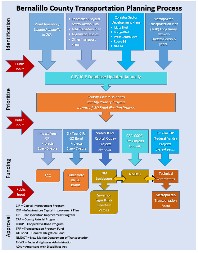
Bernalillo County Transportation Project Planning Process (2024 Archived Image)
Diagrams how Bernalillo County identifies, prioritizes, funds, and approves transportation projects through inventories, adopted plans, public input, County Commission decisions, bonds, capital outlay, impact fees, NMDOT programs, and the regional TIP. Official County image · Official County page
-
Bernalillo County Transportation Plans
Maintains the County’s current collection of transportation plans and alignment studies. The substantive documents are also preserved below so their planning history remains available if the County reorganizes or removes the originals.
-
118th Street Alignment Study (2019 archived PDF)
Establishes a preferred centerline for 118th Street to support future development, right-of-way preservation, roadway connections, drainage, utilities, and coordinated planning among Bernalillo County, Albuquerque, and NMDOT.
-
118th Street Amole Mesa to Eucariz Alignment Study (2023 archived PDF)
Extends 118th Street planning from Amole Mesa to Eucariz, documenting the recommended alignment, typical roadway section, right-of-way, drainage, utilities, environmental conditions, access, and planning-level costs.
-
Atrisco Vista Boulevard Alignment Study (2024 archived PDF)
Evaluates the future Atrisco Vista Boulevard corridor north of Double Eagle Road, addressing alignment, roadway sections, traffic, access, drainage, utilities, environmental resources, trails, right-of-way, project impacts, and preliminary costs.
-
Atrisco Vista Boulevard Phase A/B Study (2019 Archived PDF)
Evaluates Atrisco Vista Boulevard alignment, roadway and trail design, traffic, safety, drainage, access, right-of-way, environmental and cultural effects, costs, and implementation, with plan sheets, cross-sections, estimates, and drainage appendices.
This 132-page predecessor preserves the engineering appendices omitted from the smaller 2024 file. Official County PDF · Official County Project Page
-
Sunport Commerce Center Transportation Plan (2019 archived PDF)
Establishes the adopted roadway, freight, transit, bicycle, pedestrian, access, right-of-way, and capital-improvement framework for the 800-acre industrial district between Second Street, I-25, Woodward Road, and Rio Bravo Boulevard.
-
Sunport Commerce Center Design Overlay Zone (2019 Archived PDF)
Coordinates the transportation plan with adopted land-use, block, street, access, parking, landscaping, signage, architecture, drainage, utility, and development-review standards for the Sunport Commerce Center employment district.
-
Near South Valley Multimodal Study (2017 archived PDF)
Identifies gaps and priorities across the Near South Valley street, sidewalk, bicycle, trail, transit, passenger-rail, and freight networks, emphasizing accessible sidewalks, bikeway connections, safer crossings, and coordinated multimodal projects.
-
Explains Bernalillo County’s Complete Streets policy and context-sensitive approach to planning, designing, maintaining, and operating roads for pedestrians, bicyclists, transit users, motorists, and differing urban and East Mountain settings.
-
Transportation Project Planning
Describes how Bernalillo County develops transportation projects, pursues federal, state, and local funding, applies adopted plans and policies, and evaluates potential projects before design and construction.

Statewide Programming#
Current Statewide Plans#
-
Documents statewide freight conditions and investments through 2045, including Albuquerque’s I-40 bottlenecks, Sunport air cargo, rail facilities, economic role, safety needs, truck corridors, performance measures, and federally approved project priorities.
Official NMDOT PDF · Official NMDOT Multimodal Planning and Programs Bureau
-
NMDOT Public Involvement Plan (2018 Archived PDF)
Defines NMDOT’s statewide framework for involving communities in transportation decisions, including engagement goals, planning and project-development procedures, underserved populations, tribal consultation, communication tools, evaluation, and federal requirements.
Official NMDOT PDF · Official NMDOT Planning Division
-
Stakeholder and Public Outreach Appendix (2018 Archived PDF)
Preserves the survey results, stakeholder interviews, and public-comment notice used to update NMDOT’s involvement plan, including feedback from metropolitan and regional planning organizations and transportation partners. Official NMDOT PDF
-
-
New Mexico 2045 Plan (2021 archived PDF)
Establishes New Mexico’s statewide long-range transportation direction through 2045, connecting safety, asset management, mobility, multimodal access, economic vitality, environmental stewardship, performance measures, and investment strategies.
-
NMDOT Carbon Reduction Strategy (2023 archived PDF)
Defines statewide strategies and eligible investments for reducing transportation emissions through cleaner vehicles, traffic operations, transit, active transportation, travel-demand management, freight efficiency, and resilient infrastructure.
Official NMDOT PDF · Official NMDOT Research and Climate Bureau
-
NMDOT Resilience Improvement Plan (2024 archived PDF)
Assesses climate and natural-hazard risks to New Mexico transportation infrastructure, identifies vulnerable corridors and assets, and establishes resilience strategies, project priorities, and federal PROTECT funding eligibility.
Official NMDOT PDF · Official NMDOT Research and Climate Bureau
Historical Statewide Plan#
-
The New Mexico 2040 Plan (2015 archived PDF)
Preserves NMDOT’s previous statewide long-range multimodal plan, establishing goals, performance measures, strategies, and investment direction for safety, asset condition, mobility, access, stewardship, and accountability through 2040.
-
New Mexico 2040 Statewide Long-Range Multimodal Transportation Plan Briefing (2014 Archived PDF)
Documents NMDOT’s 2014 briefing to Albuquerque’s bicycle advisory committee on the developing 2040 statewide plan, including federal requirements, performance goals, project phases, stakeholder structure, surveys, and public priorities.
Official City Record · Official City PDF
Library of Congress PDF · Library of Congress catalog record · Current NMDOT Planning Division
-
Appendix A: Existing Conditions and Trends
Documents the demographic, economic, travel, freight, aviation, rail, transit, bicycle, pedestrian, highway, safety, environmental, and funding conditions used to develop the 2040 plan. Library of Congress PDF
-
Appendix B: Technical Analysis Report
Presents the technical analysis supporting the 2040 plan’s goals, performance measures, investment strategies, alternatives, health impacts, multimodal needs, and implementation recommendations. Library of Congress PDF
-
Appendix C: Scenario Analysis Report
Evaluates alternative transportation-investment scenarios, revenue assumptions, system conditions, performance outcomes, and policy tradeoffs that informed NMDOT’s selected statewide 2040 strategy. Library of Congress PDF
-
Appendix D: Stakeholder and Public Involvement
Records the statewide stakeholder, committee, tribal, agency, and public-engagement process used to shape the plan, including Albuquerque meetings, survey findings, comments, and responses. Library of Congress PDF
-
Compiles the 2040 plan’s goals, strategies, actions, responsible NMDOT divisions and partner agencies, implementation timeframes, performance measures, and annual tracking responsibilities. Library of Congress PDF
-
Project Programming#
-
NMDOT Statewide Transportation Improvement Program
NMDOT’s maintained STIP page provides the current statewide program and amendment materials for federally funded transportation projects, including projects and funding actions affecting Albuquerque.
Development Process#
-
Development Process Manual (June 2, 2020)
Provides the City’s technical requirements and procedures for planning, designing, reviewing, permitting, and constructing public infrastructure associated with development projects.
Official City PDF · Official City DPM Document Directory · Development Process Placement