Street and roadway infrastructure projects. Projects dated from 2021 through 2026 are grouped as recent; projects from 2020 or earlier are grouped as past. State highway projects are included only when they materially affect Albuquerque.
Separate Studies and Speed Management pages retain technical work and program records that are broader than individual project listings.
Recent Projects (2021–2026)#
State Highway Project Gateway#
-
District 3 is NMDOT’s Albuquerque-area office and the authoritative starting point for state-highway contacts, construction information, maintenance responsibilities, and district projects affecting the metropolitan area.
City Corridor and Neighborhood Projects#
-
Kirtland Air Force Base Access-Corridor Safety Grant Application (2026)
Documents Albuquerque’s pending $6.1 million funding request for safety, speed management, traffic signals, fiber, intelligent transportation, and gate-security improvements on Gibson, Wyoming, and Eubank near Kirtland Air Force Base.
The City submitted the application June 25, 2026. Its $6,099,328 package seeks $4,267,727 in federal funding and $1,831,601 in state or local match. As of August 14, 2026, it remains an application rather than an award and is scheduled for introduction at the August 17 Council meeting.
Official City Legislation Record · Official City Attachment · Federal DCIP Program and FY 2026 Status
-
District 7 Traffic & Street Improvements
Tracks current and completed District 7 work, including Girard streetscaping, Lomas green-stormwater and traffic calming, the Mile High Bike Boulevard, school-area safety measures, medians, crossings, and speed cushions.
-
Cutler Avenue Street Improvements
Connects the completed pedestrian project with the earlier commercial-district plan, documenting improvements between the Cutler cul-de-sac and Washington Street alongside longer-term land-use, transportation, infrastructure, safety, and economic-development recommendations.
Cutler Avenue Report (2018 Archived PDF) · Official City PDF
Pedestrian Improvements Presentation (2021 Archived PDF) · Official City PDF
-
McDuffie-Twin Parks Traffic Calming Measures
Tracks neighborhood traffic-calming construction between Carlisle, Washington, Constitution, and Lomas. Work at Washington’s Sunningdale and Constitution intersections finished in June 2026, with additional fully funded safety measures expected later in 2026.
-
Records the completed traffic-calming project on La Corrida between Comanche and San Pedro. Speed cushions were installed in 2024 after an NTMP study documented speeding and cut-through traffic; final painting and striping followed in 2025.
La Corrida Road Speed Study (2016 Archived PDF) · Official City PDF
-
Mackland and Carlisle Crosswalk
Documents the completed 2024 school-route crossing at Carlisle Boulevard and Mackland Avenue, including new striping, signs, and rectangular rapid-flashing beacons installed to improve pedestrian visibility and safety.
-
West Central Complete Streets Project
Documents the active Central Avenue safety and accessibility project, its limits, schedule, public meetings, federal Safe Streets and Roads for All funding, design concepts, and frequently asked questions.
-
West Central Complete Streets Frequently Asked Questions (2026 Archived PDF)
Explains the project scope, anticipated 2027 construction, funding, walking and bicycling facilities, drainage and intersection work, property and business access, possible speed-limit changes, transit coordination, and the 2026 public-feedback process.
-
West Central Complete Streets 60% Design Roll Plot (2026 Archived PDF)
Maps the draft 60-percent corridor design from Sarracino Place to 98th Street, documenting frontage-road reconstruction, walking and bicycling facilities, drainage, lighting, intersection geometry, access changes, and other proposed improvements.
-
West Central Complete Streets Open House Boards (2026 Archived PDF)
Presents the project area, purpose, proposed cross-sections, protected-intersection design at 98th Street, Bridge Boulevard changes, drainage, lighting, access, multimodal improvements, funding, schedule, and public-input material shown in 2026.
Project contact: Bridgette Garrett at DMD, [email protected]
-
Laurelwood Median Rehabilitation and Parkway Landscape Project
Covers the long-term Laurelwood median project, including grading, irrigation replacement, tree planting, public meetings, and the conceptual study guiding rehabilitation of the roadway median and parkway.
-
Presents the multimodal safety study for 118th Street between Dennis Chavez and Amole Mesa, including sidewalks, trails, bicycle facilities, medians, landscaping, school access, alternatives, and public-meeting material.
Public Meeting Presentation (2021 Archived PDF) · Official City PDF
-
Universe Boulevard Traffic and Pedestrian Study Public Meeting Presentation (2021 archived PDF)
Documents the study’s three-mile project limits, traffic volumes, missing sidewalks, speeding and safety concerns, and potential roundabout, lane, median, crossing, bicycle, lighting, and landscaping improvements.
-
2nd Street Rehabilitation, Sidewalk and Lighting Improvements
Describes the 2nd Street project near Hazeldine and 1st Street, combining pavement rehabilitation, traffic calming, ADA improvements, sidewalks, lighting, multimodal access, speed-study findings, and economic-development goals.
Bernalillo County Corridor Projects#
-
Isleta Boulevard Corridor Lighting
Designs LED lighting upgrades along Isleta Boulevard from Durand Road to Bridge Boulevard, ten intersections, and the I-25 Exit 213 ramps. Bernalillo County reports design at 30% with construction anticipated in 2026–2027.
Project contact: Gary Moreno-Ulibarri, 505-527-2657
-
Bridge Boulevard at Cortez Intersection
Tracks removal of the westbound slip lane, conversion of the Tower Road connector to two-way travel, new bicycle lanes and drainage, a Tower Road deceleration lane, and a median restricting truck traffic on Cortez Drive.
Project contact: Damian Luna, 505-640-6375, [email protected]
-
Tracks accessibility upgrades to sidewalks, transitions, and driveways on the east side of 2nd Street. Phase 1 was completed in June 2025; Phase 2 design is complete and awaits construction funding.
Phase 2 Project Map (2025 Archived PDF) · Official County PDF
Project contact: Gary Moreno-Ulibarri, 505-527-2657, [email protected]
-
Sunset Road Improvements: Gonzales to Neetsie
Tracks planned roadway reconstruction, bicycle lanes, sidewalk, curb and gutter, infiltration chambers, storm-drain inlets, and a pedestrian safety wall along Sunset Road. Design is complete and the project is in bidding.
Project Map (2025 Archived PDF) · Official County PDF
Project contact: Gary Moreno-Ulibarri, 505-527-2657, [email protected]
-
Sunset Road Reconstruction Phase 2
Tracks design from Bridge Boulevard to Trujillo Road for a two-lane roadway, storm drainage, curb and gutter, sidewalks, and related improvements. The County page still reports 30% design and a fall 2025 completion target.
Project Map (2025 Archived PDF) · Typical Section (2025 Archived PDF) · Official Project Map · Official Typical Section
Project contact: Jennifer Flor, 505-350-7833, [email protected]
-
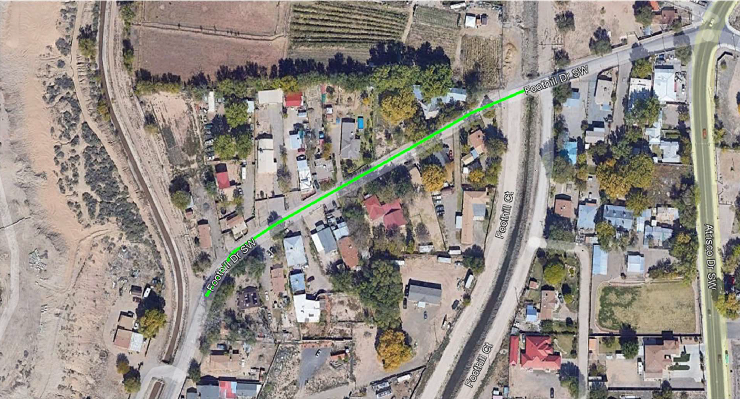
Tracks right-of-way acquisition and design for roadway and storm-drainage improvements along Foothill Drive in the Atrisco community. The County page still reports design at 30% and a February 2026 completion target.
Project Map (2025 Archived Image) · Official County Image
Project contact: Vincent Bartholdi, 505-221-4030, [email protected]
-
Isleta Boulevard Reconstruction Phase 1
Tracks design and construction preparation between Malpais and Luchetti Roads, including environmental review, right-of-way acquisition, utilities, roadway plans, drainage, bicycle and pedestrian facilities, and final procurement milestones.
Phase I Design Schedule, 2021-2026 (Archived PDF) · Official County PDF
-
4th Street Pavement Preservation
Preserves the completed 2025 milling and repaving project on 4th Street, documenting its roadway-preservation purpose, roughly $3 million construction cost, County bond funding, contractor, schedule, and project contact.
-
Atrisco Vista Boulevard Reconstruction
Tracks reconstruction and realignment from Double Eagle II Road to Paseo del Norte, including bicycle lanes, future trail grading, drainage, right-of-way acquisition, environmental review, and phased design and construction.
-
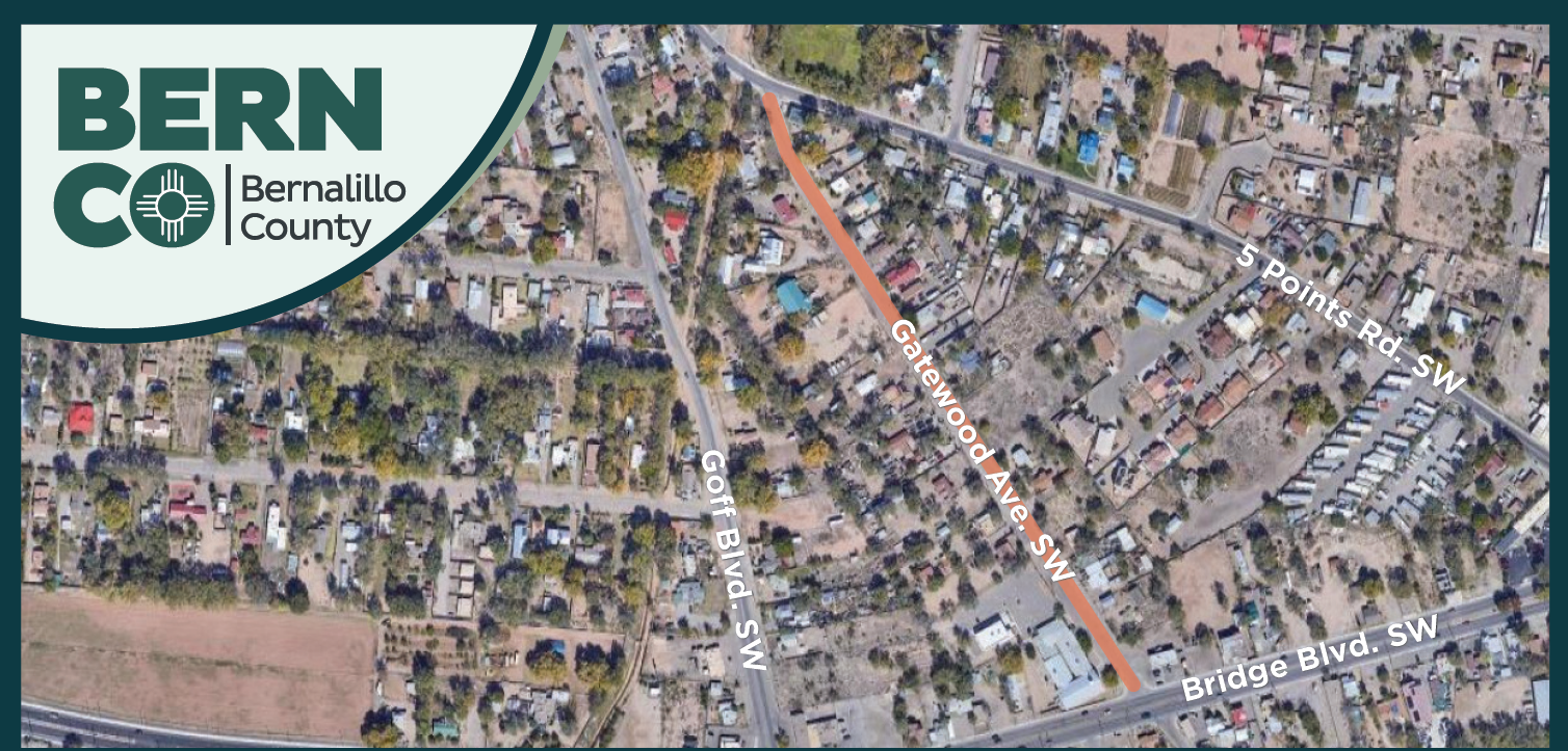
Documents the planned corridor improvements between Bridge Boulevard and Five Points Road, preserving the project geography and its relationship to Goff Boulevard, neighborhood streets, homes, and businesses.
-
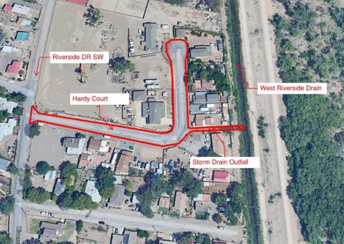
Tracks roadway and drainage improvements near Riverside Drive, including residential access, a storm-drain outfall, and the project’s relationship to the West Riverside Drain and Rio Grande bosque.
-
Rio Bravo Boulevard and Second Street Intersection
Connects the County intersection record with the natural-gas pipeline relocation needed before NMDOT replaces the Rio Bravo bridge, including safety, service, schedule, traffic, air-quality, and construction information.
Second Street and Rio Bravo Construction Schedule - February 18, 2026 (Archived PDF) · Official County Schedule
The contractor schedule tracks utility work, traffic control, paving, lighting, signals, drainage, bridge activities, milestones, completion percentages, and schedule constraints for the active intersection project.
Gas-Pipeline Relocation Resident FAQ (2025 Archived PDF) · Official County PDF
Pipeline-relocation questions: [email protected]
County project contact: Vincent Bartholdi, 505-848-1572 or 505-221-4030, [email protected]
-
Isleta Boulevard Reconstruction Phases 2 and 3
Tracks full roadway reconstruction from Luchetti Road through Don Felipe Road to Durand Road, including bicycle lanes, sidewalks, landscape buffers, drainage, intersection lighting, right-of-way work, and phased design and construction.
Phase II Design Schedule, 2024-2027 (Archived PDF) · Official County PDF
Project contact: Gary Moreno-Ulibarri, 505-527-2657, [email protected]
-
Dennis Chavez Boulevard and Condershire Drive Intersection Safety Improvements
Tracks the County safety project to add signalization, turn lanes, intersection lighting, and roadway widening at Dennis Chavez Boulevard and Condershire Drive, with design scheduled for early 2026 and construction dependent on funding.
Public Meeting Presentation (2025 Archived PDF) · Conceptual Design Board (2025 Archived PDF)
Project contact: Jennifer Flor, [email protected]
-
San Ygnacio Road and Tapia Boulevard Phase IA Improvements
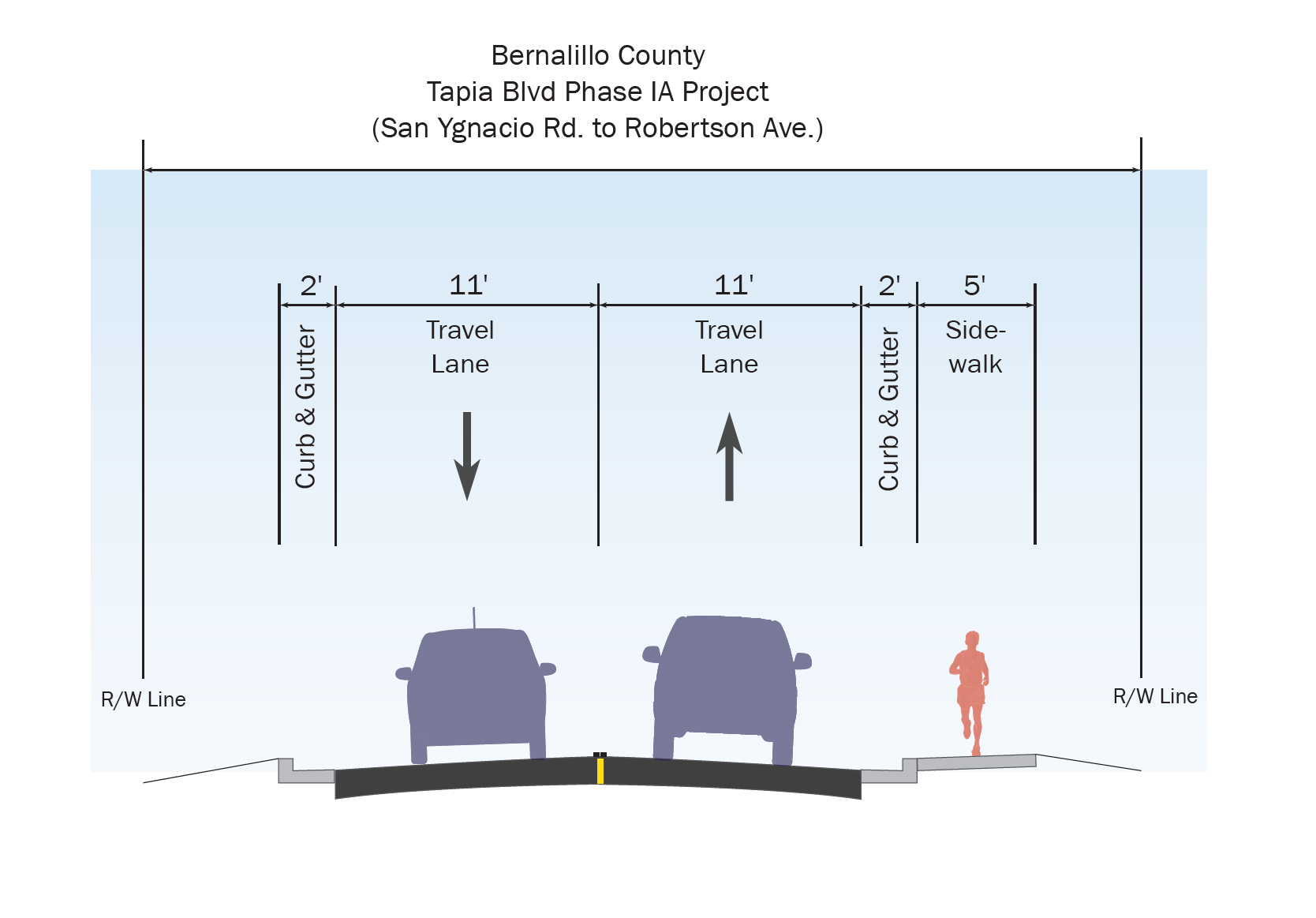
Tracks phased roadway and drainage improvements beginning on Tapia Boulevard between Robertson Avenue and San Ygnacio Road, including sidewalks, curb and gutter, right-of-way needs, 60-percent design, and currently unfunded construction.
Public Information Meeting Presentation (2025 Archived PDF)
Tapia Boulevard Phase IA Proposed Roadway Section (2025 Archived Image) · Official County Image
Project contact: Jennifer Flor, 505-350-7833, [email protected]
-
East Central Pedestrian Safety Project
Covers sidewalk and accessibility design along Central Avenue from Eubank Boulevard to Tramway Boulevard, including right-of-way mapping, utility coordination, project funding, design status, and the relationship to the earlier East Central safety study.
Archived Project Map (2025) · Official County Map · Archived Safety Study
Project contact: Richard Meadows, 505-850-4496, [email protected]
-
Tracks study and design from Lura Place to Young Avenue, including roadway reconstruction, bicycle lanes, sidewalks, drainage, access, and pedestrian and signal improvements around Goff Boulevard and Five Points.
Selected Alternative (2026 Archived PDF) · Official County PDF
Project contact: Jennifer Flor, 505-350-7833, [email protected]
-
Describes the Ortega Road-to-Alameda Boulevard redesign, combining pavement rehabilitation, bicycle lanes, ADA and pedestrian improvements, drainage, curb and gutter work, and the County’s construction schedule and funding.
Project contact: Leila Momenzadeh, 505-527-2837
-
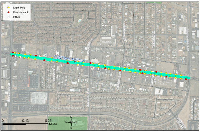
Tracks reconstruction from the Isleta Drain to Isleta Boulevard, including ADA sidewalks, buffered bicycle lanes, traffic calming, storm drainage, access management, phased design, construction timing, cost, and current County updates.
Public Meeting Presentation (2023 Archived PDF) · Official County PDF
Project contact: Dominic Ortiz, 505-301-6934, [email protected]





Additional County Corridor and Crossing Projects#
The County maintains these live project pages. Construction notices and target dates on older pages are dated records; check the source for later changes.
-
Bridge Boulevard Phase 2 - County Project Page
The County reconstruction record covers Young Avenue to La Vega Drive, with resurfacing, accessible sidewalks and ramps, bicycle lanes, adaptive signals, and street lighting. Dated traffic notices are historical; consult the County page for any new travel advisory.
-
Rio Bravo Boulevard Gap - County Project Page
The County project added a lane in each direction between Prince Street and Second Street, alongside a multi-use trail connection, sidewalks, bicycle lanes, lighting, and signals. Its page lists July 2025 completion.
-
Second Street SW Corridor Phase 2 - County Project Page
The County plan covers Second Street SW from Rio Bravo Boulevard to the South Diversion Channel, proposing resurfacing, sidewalks, curb and gutter drainage, lighting, and a pedestrian-bicycle bridge over the channel. The page lists construction bidding in 2029.
-
118th Street Alignment Study at I-40 - County Project Page
The County study examines a future 118th Street SW arterial alignment from Eucariz Avenue to Ladera Drive and the location of a possible I-40 interchange, including alternatives, drainage, right-of-way, and agency coordination.
-
Coors Boulevard SW Safety Project - County Project Page
The County project page describes planned accessibility, lighting, and other multimodal safety improvements on Coors Boulevard between Gun Club and Blake Roads. Its design and schedule figures are dated planning information, not a current completion claim.
-
Rio Bravo Adaptive Signals and Fiber - County Project Page
The County record covers adaptive signal control and fiber between Coors and Broadway on Rio Bravo Boulevard, plus fiber on Second Street to the Animal Care facility to complete the connection. Its page labels the project in closeout.
-
Central Avenue Pedestrian Hybrid Beacon - County Project Page
The County installed a pedestrian hybrid beacon on Central Avenue between Texas and Utah Streets. Its project record lists design beginning in 2019 and construction completion in July 2021.
-
Greenwich Road Improvements - County Project Page
The Greenwich Road project combines pavement, rolled curb and gutter, a south-end cul-de-sac, and infiltration chambers connected to storm-drain inlets. The County page retains a spring–summer 2024 construction snapshot; its progress figure is dated.
-
MDC I-40 Frontage Road Lighting - County Project Page
The County project designs solar corridor lighting on the I-40 South Frontage Road between Shelly Drive and Atrisco Vista Boulevard. Its design percentage and projected 2025 construction dates are historical page estimates, not a current completion claim.
-
Chico Phase 2: Ladera Road and Atrisco Vista Boulevard - County Project Page
Phase 2 extended Ladera Road from Atrisco Vista Boulevard to Comfort Way and improved Atrisco Vista near I-40, the ramps, and the Central Avenue intersection. The County page records construction completion in January 2022.
Bernalillo County Project Indexes#
-
Collects Bernalillo County’s active road, drainage, utility, facility, and community capital projects, with project locations, scope, status, schedules, contacts, and links to individual project information.
-
Finished Public Works Projects
Preserves Bernalillo County’s completed public-works project index, providing historical reference for finished roadway, drainage, facility, utility, and neighborhood improvements that are no longer listed as active.
State Project Index#
-
Maps state transportation projects in study, design, and construction, including major Albuquerque work, and provides project descriptions, development phases, public-meeting information, and links to dedicated project resources.
Unser Boulevard and Paseo del Norte#
-
Unser and Paseo Project Website
Tracks construction of Albuquerque’s $62 million Unser Boulevard and Paseo del Norte widening project, including traffic control, schedules, lane expansion, bicycle and trail connections, lighting, and stormwater improvements.
Project Documents#
-
Unser and Paseo Phase 1 Construction Fact Sheet - English (2025)
Explains Phase 1 limits, widening, bicycle lanes, multi-use trails, drainage, construction staging, the schedule through 2028 or 2029, access and traffic impacts, and the current project contact. Official project resources
-
Unser and Paseo Phase 1 Construction Fact Sheet - Spanish (2025)
Provides the same Phase 1 construction limits, multimodal improvements, sequencing, schedule, access guidance, traffic-impact information, frequently asked questions, and current project contact in Spanish. Official project resources
-
Unser and Paseo Public Meeting Presentation (2022)
Presents the combined widening project’s need, roadway concepts, multimodal design standards, bicycle and trail connections, drainage context, traffic and environmental effects, schedule, cost, funding, and public-engagement process. Official project resources
-
Biological Evaluation for the Unser Widening Project (2022)
Evaluates biological resources and potential effects of widening Unser Boulevard, documenting the project area, vegetation, wildlife, protected species, wetlands and waterways, avoidance measures, agency coordination, field observations, and environmental-clearance findings. Official project resources
-
Biological Evaluation for the Paseo del Norte Widening Project (2022)
Evaluates biological resources and environmental effects of widening Paseo del Norte, including habitat, vegetation, wildlife, protected species, waterways, field surveys, avoidance and mitigation commitments, agency coordination, and National Environmental Policy Act documentation. Official project resources
Questions or comments: email project contact Patti Watson or call 505-245-3134 (direct office) or 505-269-9691 (mobile).
Paseo del Volcan (historical proposal record)#
-
The 86-page corridor study assesses the land, market, infrastructure, and prospective return-on-investment case for building the proposed road. Official City record
-
Paseo del Volcan Right-Of-Way Acquisition Status Map (December 2013)
NMDOT’s map tabulates parcels and acres acquired and outstanding along the proposed alignment; its printed date is December 2013, not the later meeting dates in delivery filenames. Official City record
-
Places the City-owned airport’s development context alongside the proposed corridor. Official City record
I-25 Improved: Comanche to Montgomery#
-
Provides current construction phasing, traffic shifts, closures, detour maps, alerts, and contact information for NMDOT’s reconstruction of I-25, frontage roads, bridges, and interchanges between Comanche and Montgomery.
-
Interactive Planned Improvements Map
Explores the planned freeway, frontage-road, shared-use-path, ramp, bridge, and interchange changes throughout the project corridor using an interactive project viewer.
-
Planned Improvements Overview Map — Retrieved August 2026 (Archived PDF)
Maps the planned I-25, frontage-road, and interchange reconstruction from Comanche Road through Montgomery Boulevard, including lane configurations, ramps, connections, and the rebuilt Montgomery interchange.
-
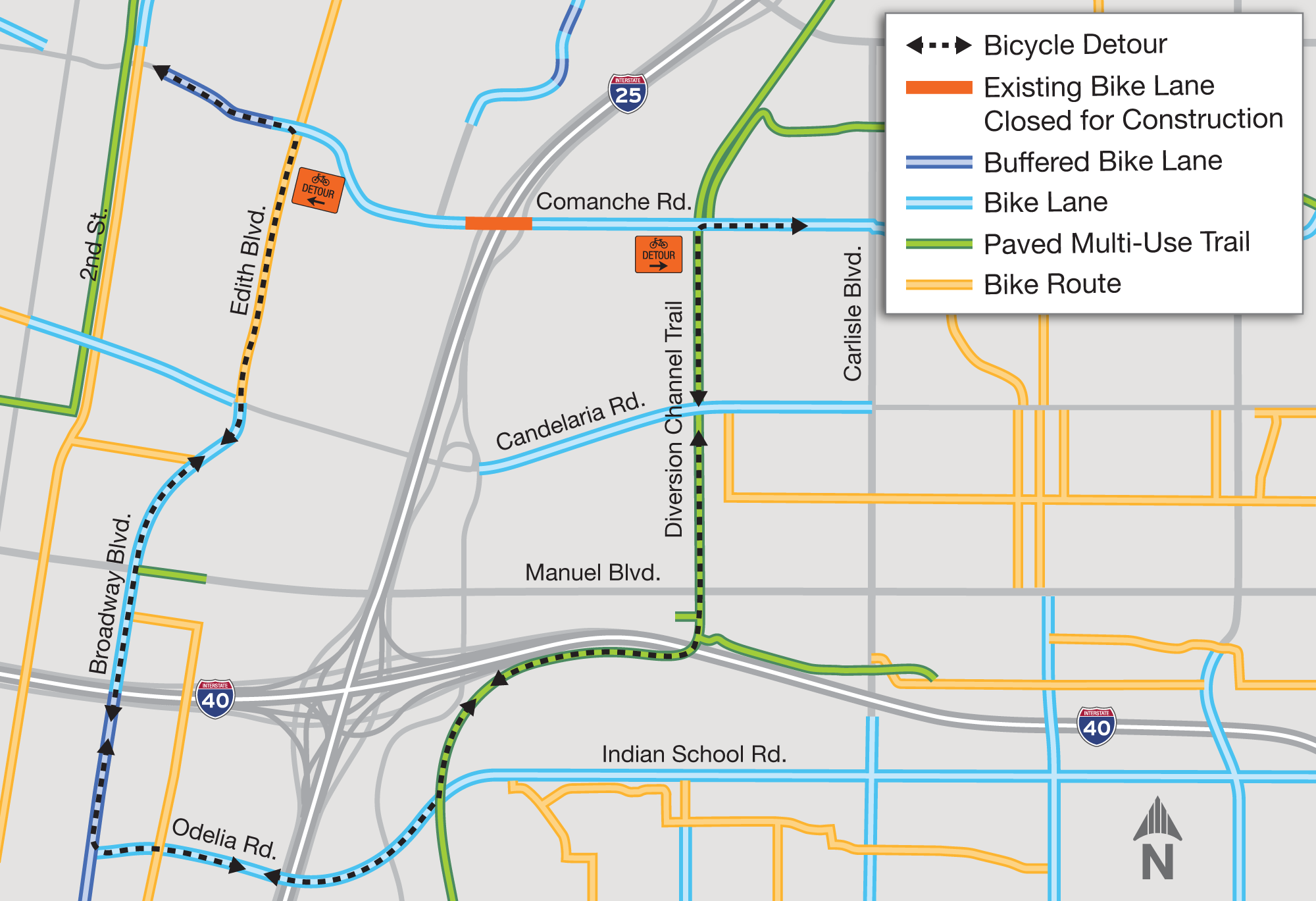
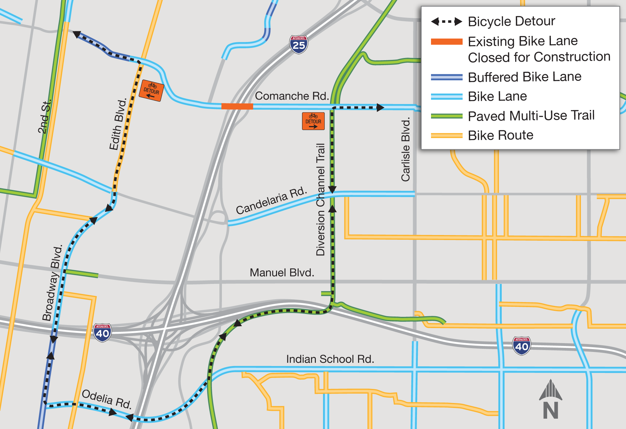
Pedestrian and Bicycle Construction Detour Map — Retrieved August 2026 (Archived Image)
Shows the project-area bicycle detour around the Comanche Road closure, connecting Edith Boulevard, Candelaria Road, the North Diversion Channel Trail, and routes near I-40.
Official Project Image · Current Pedestrian and Cyclist Information
-
Provides current lane closures, traffic shifts, delays, detours, construction phasing, travel advisories, and links to live NMRoads conditions throughout the I-25 reconstruction project.
Questions, construction concerns, or text-alert assistance: email [email protected] or call 505-785-ROAD (7623).
Broadway Boulevard Road Diet#
-
Engineering Drawings: Coal to MLK
Provides engineering drawings for the Broadway Boulevard road-diet segment from Coal Avenue to Martin Luther King Jr. Avenue, including lane layout, striping, and related improvements.
-
Draft Engineering Drawings: MLK to Lomas
Shows the draft road-diet design from Martin Luther King Jr. Avenue to Lomas Boulevard, documenting proposed lane configuration, striping, and intersection details.
-
Presents the 60-percent design cost estimate for the Broadway segment between Martin Luther King Jr. Avenue and Lomas Boulevard, organized by anticipated construction items.
-
Traffic Evaluation (Signed July 2, 2025)
Evaluates traffic operations and engineering considerations for the proposed Broadway Boulevard road diet, providing the signed technical basis for the project’s lane changes.
Citywide Construction Maps#
-
Permitted Construction in the Public Right of Way
The City’s regularly updated map shows permitted right-of-way construction, locations, dates, descriptions, and responsible contractors, helping residents distinguish current City-jurisdiction work from state and emergency projects.
-
Fiber Installation Barricades Map
Maps current and future fiber-installation barricade permits by company and status, helping users identify telecommunications work that may affect Albuquerque streets and travel.
-
Lists current event and seasonal construction moratoriums, affected street boundaries, downloadable maps, dates, and the live map used to coordinate safe traffic operations during major Albuquerque events.
Past Projects (2020 and Earlier)#
County Street and Crossing History#
-
Bridge Boulevard Phase 1 - County Project Page
The first County reconstruction phase addressed Bridge Boulevard west of Goff to Old Coors and Tower Road toward Coors, with intersection, sidewalk, accessibility, drainage, and lighting work. The page records construction starting in 2020.
-
Second Street Landscaping Project - County Project Page
The County project used native landscaping, irrigation, and green stormwater methods along Second Street, supported by a Great Urban Parks grant and County trail bonds. The page records completion in July 2019.
-
Second Street Quiet Crossing - County Project Page
The County record documents road, sidewalk, curb, and gutter work needed to activate the rail quiet crossing at Second Street and Prosperity Avenue. It lists construction completion in February 2020.
-
Atrisco Heritage High School 118th Street Improvements - County Project Page
The County added a curb and extended the trail along 118th Street at Atrisco Heritage High School. Its project page records state funding and December 2018 construction completion.
-
Sage Road and Old Coors Road Intersection - County Project Page
The County project added dedicated turn lanes, permanent signals, lighting, and accessible crossings at Sage Road SW and Old Coors Road SW. The page describes the intersection work as completed.
-
Paradise Hills ADA Improvements Phase 1 - County Project Page
The County replaced deficient wheelchair ramps, curbs, sidewalks, and pavement markings in Paradise Hills under its ADA transition and Complete Streets work. The project page records completion in November 2018.
-
Tramway Lane Reconstruction - County Project Page
The County reconstructed Tramway Lane pavement from Tramway Boulevard to Tramway Lane Court by reworking the existing asphalt and placing a new surface. Its project page records completion in August 2015.
-
County Road Improvements District 4 - County Project Page
The County road-bond project repaved San Bernardino Road from Eubank to Holbrook, Ortega Road from Second Street to Edith, and San Francisco Road from Lowell to Tennyson. The project page records the 2019 work as completed.
Rainbow Boulevard and Universe Boulevard School Safety Project#
-
The enacted City resolution creates a traffic and pedestrian safety project on Rainbow and Universe Boulevards, directing lighting, safety, and street improvements and appropriating funds from the Transportation Infrastructure Tax Fund 340 for the school corridor.
Bernalillo County Capital Cooperative and School Bus Route Projects (2015–2022)#
-
Capital Cooperative and School Bus Route Road Improvements (2015)
Records two phases of road construction: Meadows Drive in the East Mountains and six Paradise Hills streets, with capital cooperative and school-bus funding.
-
Capital Cooperative and School Bus Route Road Improvements (2016)
Lists East Mountain, Industrial Road, and Eubank Road paving work, funding, design status, and a $621,360.73 construction cost under the County capital cooperative and school-bus programs.
-
Capital Cooperative and School Bus Route Road Improvements (2017)
Records pavement, drainage, and culvert work on Ranchitos Road, Calle de lo Sur, Calle de Oriente, Quail Run, and La Vuelta Drive under the County program.
-
Capital Cooperative and School Bus Route Road Improvements (2018)
Documents Foothill Road asphalt overlay, speed-hump reconstruction, culvert work, funding sources, schedule, and $559,169 construction cost for the 2018 County roadway project.
-
Capital Cooperative and School Bus Route Road Improvements (2019)
Documents resurfacing of various roads in County districts 4 and 5, including the state-County funding split, project team, construction season, and completion status.
-
Capital Cooperative and School Bus Route Road Improvements (2020)
Documents repaving of Timan Avenue in Paradise Hills and Kennedy Lane and Longview Drive in the East Mountains, including funding, schedule, and project status.
-
Capital Cooperative and School Bus Route Road Improvements (2021)
Records resurfacing of William and La Vega roads in District 2 and Holli Loop in the East Mountains, with 75 percent state and 25 percent County funding.
-
Capital Cooperative and School Bus Route Road Improvements (2022)
Records completion of Pino Avenue and Holli Loop resurfacing in County districts 4 and 5, funded 75 percent by the state and 25 percent by Bernalillo County.
-
Barcelona Road Storm Drain Project Phase 2A
Preserves the completed 2019-2020 roadway and drainage project between Joe Sanchez and La Junta Roads, which connected runoff to the Armijo Drain and added bicycle lanes, curb and gutter, and sidewalk.
-
Paseo del Norte Access to Fire Station 35
Preserves the completed frontage-road access project serving Fire Station 35, including the station, access road, Eubank and Tramway boulevards, neighborhood streets, drainage corridors, and surrounding North Albuquerque Acres area.
-
Bernalillo County Transportation Projects Update (2015 Archived PDF)
Summarizes the County’s April 2015 transportation portfolio, documenting scope, cost, and schedules for Bridge, Tower, Second Street, Rio Bravo, Sunport, Woodward, Sunset, Old Coors, and other roadway and trail projects.
Official County PDF · Official County Finished-Projects Index
-
Edith Boulevard and Vineyard Road Improvements
Preserves the completed Edith Boulevard mill-and-overlay and Vineyard Road reconstruction record, including sidewalk repairs and the relationship of the work to Osuna Road, Second Street, and North Valley neighborhoods.
-
Alameda Boulevard Median Landscape Renovation Phase II
Preserves the County’s Phase II median-landscape project record, including planting layouts, irrigation and landscape elements, roadway context, and the limits of the completed Alameda Boulevard renovation.
-
Preserves the second phase of Sunset Gardens Road drainage improvements, distinguishing it from completed Phase 1 and locating the corridor, detention pond, waterways, and surrounding South Valley streets.
-
Tower Road SW Roadway and Utility Improvements
Preserves the completed roadway and utility project east of Unser Boulevard, including its short improvement segment, adjacent parcels and streets, and relationship to Albuquerque’s west-side roadway network.
-
Preserves the Woodward Road improvement corridor between Second Street and Broadway Boulevard, with geographic context for the railroad, drains, canals, parcels, industrial streets, and Rio Grande.
-
Blake Road and Coors Boulevard Improvements
Preserves the County’s phased Blake Road and Coors Boulevard construction record, showing work limits around the intersection and nearby South Valley streets, properties, development, and the final segment east of Coors.
Phases 1–5 Map (2021 Archived PDF) · Phase 6 Map (2021 Archived PDF) · Official Phases 1–5 PDF · Official Phase 6 PDF
-
Preserves the County project record for rebuilding Goff Boulevard between Bridge and Arenal roads, including roadway and drainage design, detention ponds, storm-drain connections, project limits, and the 2013 community presentation and map.
Community Meeting Presentation (2013 Archived PDF) · Project Map (2013 Archived PDF)
-
Second Street SW Corridor Improvement Project
Preserves the County project record for 1.5 miles of Second Street SW reconstruction serving Valle de Oro, including roadway, railroad-crossing, drainage, sidewalk, multi-use-trail, bridge, landscaping, environmental, and public-involvement material.
Open House Boards (2016 Archived PDF) · Project Map (2016 Archived PDF)