Bicycle infrastructure projects.
Projects dated from 2021 through 2026 are grouped as recent. Projects from 2020 or earlier are grouped as past, avoiding uncertain judgments about whether construction or closeout is still active.
Recent Projects (2021–2026)#
Tom Bolack Urban Forest Trail Improvements#
-
Documents the completed trail paving and solar-lighting project south of I-40 between Louisiana and San Pedro, including PNM utility coordination, the concrete connection near the dog park, construction sequencing, and before-and-after photographs.
Dr. Martin Luther King Jr. Avenue Separated Bicycle Lane Pilot#
-
Tracks the separated-lane pilot on Dr. Martin Luther King Jr. Avenue, including project limits, safety purpose, installation approach, evaluation period, frequently asked questions, and relationship to the adopted Bikeway and Trail Facilities Plan.
-
Pilot Project FAQ (2026 Archived PDF)
Explains the pilot limits, safety purpose, separation materials, intersection treatments, maintenance evaluation, ridership data collection, community feedback, and relationship to the adopted Albuquerque bicycle priorities.
-
Pilot Project FAQ in Spanish (2026 Archived PDF)
Provides the City’s Spanish-language explanation of the pilot limits, safety basis, separation materials, intersection treatments, maintenance evaluation, ridership data, community feedback, and relationship to Vision Zero and adopted bicycle priorities.
Questions or comments about this pilot: Valerie Hermanson at DMD, [email protected]
Buena Vista Bike Boulevard#
Location: Buena Vista Dr SE, from Central Ave SE to Gibson Blvd SE
-
Buena Vista Bike Boulevard 60% Plans
Shows the 60-percent design for bicycle-boulevard improvements along Buena Vista Drive, including traffic-calming, crossing, signing, pavement-marking, and corridor layout details.
-
Buena Vista Bike Boulevard Project Roll Plot (August 2026)
Provides an August 2026 aerial roll plot of the Buena Vista Bike Boulevard from Gibson Boulevard to Central Avenue, identifying proposed signs, pavement markings, speed cushions, crossings, signals, parking restrictions, and pavement work.
Questions or comments email Paul Olson at DMD [email protected]
Moon Street Cycletrack / Bike Boulevard#
Location: Moon Street NE, between Academy Rd NE and Spain Rd NE
-
Moon Street NE Cycletrack Plans
Documents the planned Moon Street restriping and cycletrack layout between Academy and Spain, including bicycle facilities, lane configuration, markings, and intersection treatments.
Questions or comments email Melissa Roseman at DMD [email protected]
Alameda Drain Trail Phase 6#
-
Bernalillo County Project Page
Tracks design and permitting for a shared-use trail beside the Alameda Drain west of 2nd Street, from Alameda Boulevard to Vista Azul Lane, with landscaping, trail amenities, and stormwater-quality improvements.
The foundational Alameda Drain and Trail Master Plan is archived under Bike Plans.
Project contact: Leila Momenzadeh, 505-252-2837, [email protected]
Alameda Drain Trail Phase 4#
-
Alameda Drain Trail Phase 4 - County Project Page
This County trail phase runs from El Pueblo Road to Alameda Boulevard, continuing the shared-use route with landscaping and water-quality features at drain outfalls. The project page reports completion in October 2025.
Past Projects (2020 and Earlier)#
Alameda Drain Trail Earlier Phases#
-
Alameda Drain Trail Phase 1 - County Project Page
The first County phase runs beside the Alameda Drain between Montano and Osuna Roads, adding shared-use trail space, landscaping, amenities, and water-quality work at stormwater outfalls. The source reports the 2018-2019 construction period.
-
Alameda Drain Trail Phase 2 - County Project Page
The County phase extends the shared-use trail along the Alameda Drain from Osuna Road to El Pueblo Road, with landscaping, trail amenities, and stormwater-quality features. It is part of the nine-mile master-plan corridor.
Second Street Trail#
-
Second Street Trail Phase 1 - County Project Page
The first County trail phase built an approximately one-mile, 10-foot-wide asphalt route along the east side of Second Street from the South Diversion Channel to Prosperity Avenue. The page records completion in 2016.
-
Second Street Trail Phase 2 - County Project Page
The County page documents the approximately one-mile, 10-foot-wide asphalt trail along the east side of Second Street from Prosperity Avenue to Rio Bravo Boulevard, following the earlier South Diversion Channel segment.
Other County Bicycle Projects#
-
Eubank Trail - County Project Page
The County project built a paved trail, drainage improvements, and bicycle-lane striping along Eubank Boulevard from Wilshire to Alameda; its source records 2017 construction and completion.
-
Rio Grande Boulevard Bike Lane Improvements - County Project Page
The County project describes widening Rio Grande Boulevard from the Los Ranchos boundary to Alameda Trail for on-street bicycle lanes, with possible sidewalk work, pavement rehabilitation, utility relocation, and irrigation-canal improvements. The page dates construction to 2017.
Paradise Hills Trail#
-
Conceptual Improvements Map (2013 Archived PDF)
Maps the 2013 Paradise Hills Trail concept along Paradise Boulevard and Unser Boulevard, distinguishing proposed new asphalt trail from existing trail upgrades and locating the project within the surrounding street network.
Silver Avenue Bike Boulevard Review#
-
Silver Avenue Bike Boulevard Review (2019 Archived PDF)
Evaluates the Silver Avenue and 14th Street bike boulevards from Yale to the Bosque, documenting traffic, crashes, public input, I-25 and railroad crossing alternatives, route treatments, costs, and recommended improvements, with a qualitative review of Mountain Road.
-
City Council Resolution R-2020-079 (Archived PDF)
Adopts the Silver Avenue Bike Boulevard Review as City policy priorities for the corridor between Yale Boulevard and the Paseo del Bosque Trail and directs implementation, funding, coordination, and incorporation into future bicycle planning.
I-25 Bicycle Accessibility Study#
-
I-25 Bicycle Accessibility Study Summary (2020; Updated 2021 Archived PDF)
Summarizes the 2019–2020 study of bicycle access across northern Albuquerque’s I-25 crossings, recommending corridor, trail, lane, signage, and network improvements while identifying San Francisco Street and San Diego Avenue as potential future bicycle-pedestrian crossings.
Former City PDF · Official 2024 Bikeway and Trail Facilities Plan
Uptown Pedestrian, Bicycle, and Wayfinding Program#
-
Uptown Pedestrian and Bicycle Plan and Wayfinding Program (2008 archived PDF)
Develops an Uptown walking, bicycling, shuttle, parking, circulation, public-space, branding, and wayfinding framework intended to help the district evolve into a compact, mixed-use, pedestrian-oriented activity center.
Official City PDF · Official City transit document collection
San Pedro Drive and Mile-Hi#
-
San Pedro Drive Bike Facility Assessment (2014 archived PDF)
Evaluates a San Pedro Drive road diet and bicycle facilities through traffic volumes, intersection operations, future growth, crash history, access, parking, transit, design alternatives, and public feedback.
Mountain Road Bike Boulevard at San Pedro Drive#
-
Crossing Alternatives Presentation (2015 archived PDF)
Preserves the GABAC presentation evaluating crossing concepts for the offset Mountain Road bike boulevard at San Pedro Drive, including access concerns, design precedents, alternatives, and recommendations.
MLK Avenue and Broadway Boulevard Two-Stage Bike Box#
-
Two-Stage Bike Box Guide (archived PDF)
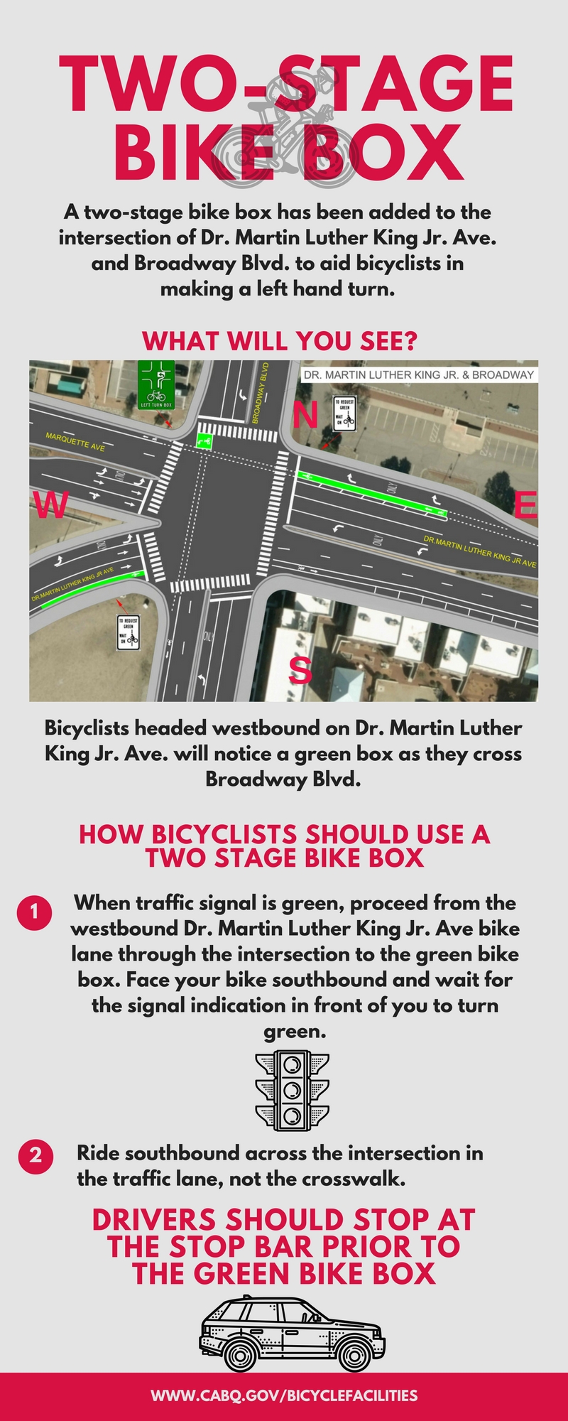
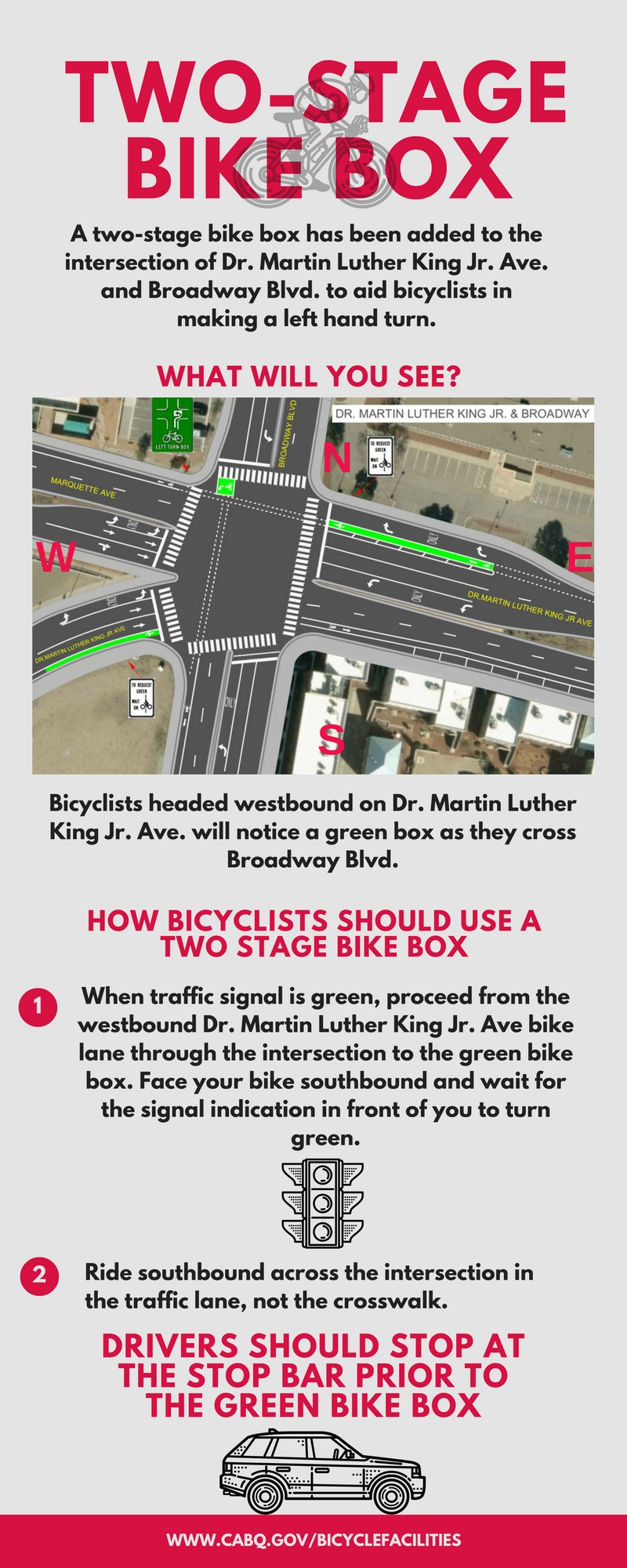
Illustrates the two-stage bicycle left-turn process at Dr. Martin Luther King Jr. Avenue and Broadway Boulevard, showing rider positioning, signal sequence, travel path, and driver stop location.
View archived image · Official City PDF · Official City image