Historical area, sector, and community plans that explain how Albuquerque neighborhoods, infrastructure, land use, and transportation developed. Many no longer control zoning, but remain important planning-history records.
-
City Area & Sector Development Plan Library
Maintains the City’s current reference index for adopted historical plans. ABQInfo preserves selected complete plans and adoption records whose context remains independently useful.
Citywide Growth Strategy#
The Planned Growth Strategy is a historical City and County study of future growth in Albuquerque and Bernalillo County. It examines development patterns and land-use alternatives alongside infrastructure costs, public services, level-of-service standards, finance, regulatory approaches, and City/County responsibilities. It is a planning-history record, not a statement of current zoning rules.
-
Planned Growth Strategy, Part 1 — Complete Findings Report (286 Pages)
The complete City original documents existing conditions, development trends, alternative growth scenarios, infrastructure costs, and economic impacts. Official City PDF
Part 2, the Preferred Alternative, was published by the City as separate chapter PDFs. All 11 named chapters are represented below by 12 files because Chapter 1.0 has two deliveries. No verified complete combined Part 2 original has been located, so the City originals appear in documented order rather than as a merged PDF.
Archived Part 2 chapters (each link is a separate original City PDF):
- Chapter 1.0a — Introduction and Rationale, first half · Official City PDF
- Chapter 1.0b — Introduction and Rationale, second half · Official City PDF
- Chapter 2.0 — Subarea Descriptions · Official City PDF
- Chapter 3.0 — Preferred Alternative Summary · Official City PDF
- Chapter 4.0 — Mixed-Use Redevelopment Examples · Official City PDF
- Chapter 5.0 — Level of Service Standards · Official City PDF
- Chapter 6.0 — Financial Implementation · Official City PDF
- Chapter 7.0 — Regulatory Structure Approaches · Official City PDF
- Chapter 8.0 — Level of Service and Finance · Official City PDF
- Chapter 9.0 — City/County Requirements · Official City PDF
- Chapter 10.0 — Growth Strategy Techniques Used in Other Locations · Official City PDF
- Chapter 11.0 — Regulatory Structure Outline · Official City PDF
Enabling legislation#
The broader Planned Growth Strategy study is historical planning analysis. These three ordinances identify specific measures the City enacted; they did not make the entire study law. The linked originals are historical enactments, not current consolidated law or current forecasts.
-
O-2002-034 — Growth-management framework (F/S O-02-39 (2), 2002)
Established the City growth-management framework and advisory task force, with impact-fee principles, infrastructure and Capital Improvements Program (CIP) sequencing, a no-net-expense development policy, and intergovernmental coordination. Official City original
-
O-2003-047 — Infrastructure and growth forecasts (O-03-132, 2003)
Adopted population, housing and employment forecast tables for growth-related capital planning and the land-use assumptions used for development fees. The original includes all three forecast exhibits. Official City original
-
O-2004-007 — Development Fees Act land-use assumptions (O-04-9, 2004)
Adopted the later land-use assumptions and forecast framework under the Development Fees Act for growth capital needs and development impact fees, with a five-year update requirement. Its population, housing and employment tables differ from the 2003 ordinance and are preserved here as a distinct enactment. Official City original
Downtown Neighborhood Area#
-
Downtown Neighborhood Area Sector Development Plan Update (Draft, September 17, 2010; multipart)
City draft plan for the Downtown Neighborhood Area, covering history, assets, goals, implementation, zoning regulations, a proposed-zoning map, and an action agenda. This four-file draft was published for review and should not be read as an adopted plan.
Central Avenue Station-Area Planning#
-
Central Avenue Station-Area Planning — September 2017 historical public-comment package
This City-commissioned station-area and corridor strategies report connected ART investment with Central Avenue development, public-realm improvements, equity, financing and implementation priorities. Its eleven continuously paginated sections form one report released for public comment in September 2017. It was a nonbinding draft, not an adopted plan.
Official project provenance is established through City grant and procurement records, contemporaneous public-release evidence, and comparison with the revised study later delivered by the City. These eleven preserved originals remain useful together as the historical public-review package, recording proposals presented before revision. Archived project public-release page.
The 2018 revised completed study superseded this draft as the completed study; that relationship does not establish adoption of the proposed plan amendment. The adopted 2014 Route 66 Action Plan, Comprehensive Plan and Integrated Development Ordinance (IDO) remained separate governing instruments. The City’s published plan index lists the completed study separately from the adopted Route 66 plan.
Preserved report components (eleven sections): Introduction and Action Plan · Station Types · West Central · Old Town · Downtown · East Downtown · University Area · Nob Hill · International District · Equity and Inclusion · Finance
Separate supporting draft: Infrastructure — Crabtree supporting assessment/draft examines corridor utility capacity and infrastructure assumptions. Released alongside Finance, it is a separate supporting assessment, not section 12 of the continuously paginated report; it is absent from the 2018 combined study.
Near Heights#
-
Near Heights Community Planning Area Assessment (2022; Accepted 2023 Archived PDF)
Documents Near Heights land use, transportation, housing, economic conditions, community facilities, public engagement, proposed projects, policy priorities, and performance metrics across the International District, Nob Hill, university area, and surrounding neighborhoods.
Current City CPA Assessment Page · Internet Archive Capture of Former City PDF
Sunport Commerce Center#
-
Sunport Commerce Center Design Overlay Zone (2019 Archived PDF)
Establishes the adopted design overlay for Sunport Commerce Center, coordinating land use, multimodal circulation, street and block design, access, parking, landscaping, signage, architecture, drainage, utilities, and development review around the airport employment district.
Official County PDF · Check the current County transportation-plan library
South Coors Boulevard#
-
South Coors Boulevard Sector Development Plan
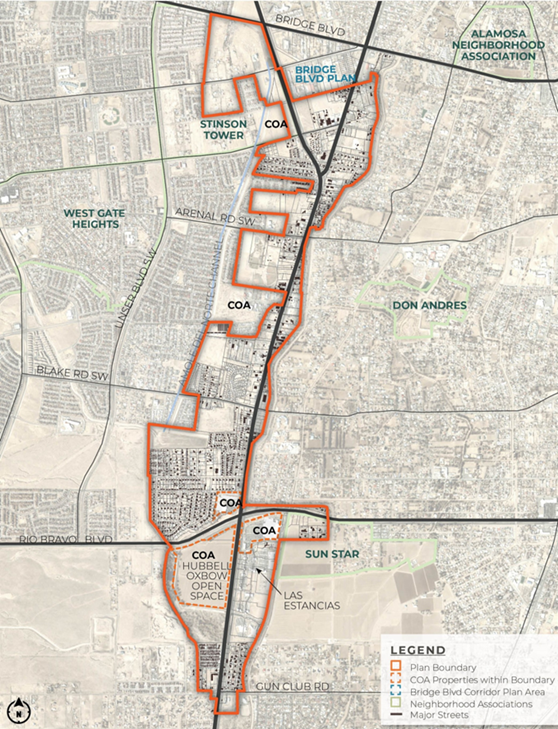
Tracks the County planning effort for the South Coors corridor from Bridge Boulevard to Gun Club Road, including community activity areas, neighborhoods, County properties, major streets, and its relationship to the Bridge Boulevard plan area.
Planning Boundary Map (2025 Archived Image) · Official County Image

Barelas#
-
Barelas Sector Development Plan (Adopted April 2008; Archived PDF)
Preserves the Barelas Sector Development Plan adopted in April 2008, covering neighborhood land use and design. This historical sector plan is distinct from the Barelas Neighborhood Commercial Area Revitalization Plan.
Related record: Barelas Neighborhood Commercial Area Revitalization Plan, preserved separately with its commercial-area redevelopment context.
Southwest Mesa and Volcano Area#
-
Southwest Area Plan (Bernalillo County 2001; Albuquerque 2002)
Preserves the jointly adopted Southwest Area Plan covering growth, land use, transportation, infrastructure, community form, environmental resources, public facilities, economic development, implementation, and City and County responsibilities.
-
Volcano Mesa Plans — Proposed Transportation Text Amendments (2014 Archived PDF)
Explains proposed 2014 transportation amendments across the Volcano Cliffs, Volcano Heights, Volcano Trails, and West Side plans, comparing roadway-network maps, Paseo del Norte and Unser cross-sections, frontage roads, and multimodal design.
-
Volcano Trails Sector Development Plan with Adopting Legislation (As Enacted 2011; Archived PDF)
Preserves the enacted August 2011 Volcano Trails plan package with adopting legislation. It complements the separately held plan and adoption resolution below; these are related deliveries, not the same original.
-
Volcano Trails Sector Development Plan (2011)
Preserves the adopted Volcano Trails framework for village-center and residential development, open space, transportation, trails, infrastructure, urban design, zoning, implementation, and protection of the volcanic landscape.
-
Volcano Trails Environmental Planning Commission Official Notice of Decision (2011 Archived PDF)
Records the Environmental Planning Commission’s recommendation to approve the Volcano Trails plan, including findings, zoning analysis, agency comments, public testimony, and detailed conditions forwarded to City Council.
-
Volcano Trails Sector Development Plan Adoption Resolution R-11-211 (2011)
Records City Council’s adoption and zoning actions for the 446-acre Volcano Trails plan area, including village center, residential districts, open space, boundaries, findings, and implementation conditions.
Fourth Street and Montaño#
-
Fourth Street and Montaño Community Visioning Report (2004)
Documents community priorities for the Fourth Street and Montaño area, including traffic, pedestrian safety, drainage, neighborhood character, commercial development, public space, land use, and coordinated improvement strategies.
-
North Fourth Street Rank III Corridor Plan — City Council Draft (2010 Archived PDF)
Preserves the 133-page City Council draft combining corridor history, form-based zoning, building and frontage standards, transportation and street design, and redevelopment strategies for North Fourth Street from Mountain Road to the Los Ranchos boundary.
-
North Fourth Street Background and Resources Materials (2009 Archived PDF)
Preserves the plan’s companion research volume, including negotiated community recommendations, demographics, land use, real-estate and business conditions, traffic and transit analysis, urban-design studies, streetscape cost estimates, and historic-preservation material.
-
North Fourth Street Existing Zoning Map (December 2009 Archived PDF)
Maps the zoning districts in effect along the North Fourth Street study corridor in December 2009, providing a historical baseline for interpreting the plan’s proposed form-based overlay and redevelopment recommendations.
-
North Fourth Street Form-Based Overlay Zone Map (December 2009 Archived PDF)
Maps the North Fourth Street plan’s proposed transit-oriented, mixed-use, and infill-development overlay districts in December 2009, showing the corridor and study boundaries used during the City Council draft process.
Los Duranes#
-
Los Duranes Sector Development Plan — Draft Vision and Goals (September 2009 Archived PDF)
Sets out the community draft vision and goals for family heritage, land and water, agriculture, housing, mobility, and neighborhood character during preparation of the Los Duranes Sector Development Plan.
Official City Council document collection · Official City PDF
-
Los Duranes Sector Development Plan — Neighborhood Review Draft (May 2010 Archived PDF)
Presents the complete neighborhood-review draft of the Los Duranes Sector Development Plan, including conditions, vision, land use, transportation, acequias, design standards, implementation, and proposed zoning before 2012 adoption.
Official City Council document collection · Official City PDF